
Geoheritage Site Resource Collection
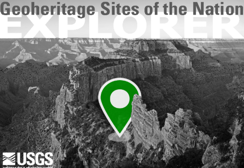
The U.S. Geological Survey (USGS) has identified 55 significant geologic sites in the U.S which demonstrate geoheritage values. Visit the Geoheritage Sites of the Nation Explorer and search the collection of educational resources below to learn about specific geoheritage sites.
What is Geoheritage?
Think about a place that holds meaning for you. Why is this place important to you? When did you first go there? Is it a place that attracts a lot of people? What about it makes you (and others) want to keep going back?
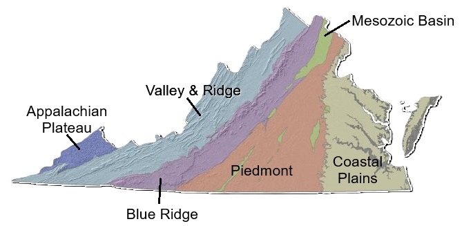
Geoheritage refers to geological features and sites that hold significant value (Geoheritage Values Summary) and not only help us understand Earth’s history, but also offer a window into human history. In Virginia, diverse geological formations across the state have impacted human settlements in many ways that align with geoheritage values.
Geoheritage Site List
Click here to view the complete list of U.S. geoheritage sites. Sites that are green have associated educational resources in the database below.
U.S. Disticts and Territories:
- American Samoa: Vai’ava Strait of Pola Island, National Park of American Samoa
- Guam: Ritidian Point, Guam National Wildlife Refuge
- Puerto Rico: La Coca Falls, El Yunque National Forest
- Virgin Islands: Ram Head, Virgin Islands National Park
- Washington, DC: Pulpit Rock, Rock Creek Park
U.S. States:
- Alabama: Little River Canyon, Little River Canyon National Preserve
- Alaska: Exit Glacier, Kenai Fjords National Park
- Arizona: The Great Unconformity, Grand Canyon National Park
- Arkansas: The Giant Flowstone of Blanchard Springs Caverns, Ozark-St. Francis National Forest
- California: Devils Postpile, Devils Postpile National Monument
- Colorado: Marsh-Felch Quarry, Garden Park Fossil Area
- Connecticut: The Truants’ Meadow outcrop, Weir Farm National Historical Park
- Delaware: Wissahickon Formation of the Delaware Piedmont, First State National Historical Park
- Florida: Hammock Sink, Apalachicola National Forest
- Georgia: Cumberland Island Salt Marsh, Cumberland Island National Seashore
- Hawaii: Kilauea Caldera, Hawai’i Volcanoes National Park
- Idaho: Sheep Rock, Payette National Forest
- Illinois: Camel Rock, Shawnee National Forest
- Indiana: West Beach Dunes, Indiana Dunes National Park
- Iowa: Hanging Rock, Effigy Mounds National Monument
- Kansas: Flint-rich limestone, Tallgrass Prairie National Reserve
- Kentucky: Cumberland Gap, Cumberland Gap National Historical Park
- Louisiana: Wolf Rock Cave, Kisatchie National Forest
- Maine: Cadillac Mountain, Acadia National Park
- Maryland: Catoctin Mountain , Catoctin Mountain Park
- Massachusetts: Race Point Beach, Cape Cod National Seashore
- Michigan: Monument Rock, Isle Royale National Park
- Minnesota: Tar Point, Voyageurs National Park
- Mississippi: Ship Island, Gulf Islands National Seashore
- Missouri: Cowards Hollow, Mark Twain National Forest
- Montana: Pompeys Pillar, Pompeys Pillar National Monument
- Nebraska: Scotts Bluff, Scotts Bluff National Monument
- Nevada: Great Basin Curvilinear Style Petroglyph, Hickison Petroglyph Recreation Area
- New Hampshire: Tuckerman Ravine, White Mountain National Forest
- New Jersey: Passaic Falls, Paterson Great Falls National Historical Park
- New Mexico: Dunes of White Sands National Park
- New York: Wilderness Beach, Fire Island National Seashore
- North Carolina: Looking Glass Rock, Pisgah National Forest
- North Dakota: Two-Top Mesa and Big Top Mesa, Dakota Prairie Grasslands|National Natural Landmark
- Ohio: The Ritchie Ledges, Cuyahoga Valley National Park
- Oklahoma: Bromide Hill, Chickasaw National Recreation Area
- Oregon: Metolius Balancing Rocks, Deschutes National Forest
- Pennsylvania: Devil’s Den, Gettysburg National Military Park
- Rhode Island: Price Neck Formation, Sachuest Point National Wildlife Refuge
- South Carolina: Weston Lake, Congaree National Park
- South Dakota: Sod Tables of the Badlands, Badlands National Park
- Tennessee: Cades Cove, Great Smoky Mountains National Park
- Texas: Guadalupe Peak, Guadalupe Mountains National Park
- Utah: Landscape Arch, Arches National Park
- Vermont: Deer Leap Rock, Green Mountain National Forest
- Virginia: Mather Gorge, Great Falls Park
- Washington: Mount St. Helens, Gifford Pinchot National
- West Virginia: New River Gorge sandstone cliffs, New River Gorge National Park & Preserve
- Wisconsin: Devils Island, Apostle Islands National Lakeshore
- Wyoming: Old Faithful Geyser, Yellowstone National Park
Strategies for using various resource types with students
Click here for ideas on how to use articles, maps, artwork, videos, music, or data within geoheritage lessons.
Reading:
- Search for key vocabulary within the reading that focus on the physical features or geological processes of the area.
- Highlight sections of the reading that match with geoheritage values.
Map:
- Identify specific geologic features or evidence of processes like erosion, metamorphism, or volcanic eruptions.
- Compare and contrast what different maps of the same area show.
- Compare and contrast maps between geoheritage sites to see differences in their features.
- How does the map help you to understand more about this area?
Artwork:
- Compare drawings and photographs from different time periods to describe how the area has changed over time (natural or human impact).
- Identify specific geological features or evidence of processes. Are they the focus of the artwork or are they secondary features?
- How does the artwork convey how the artist feels about the location?
- Create your own artwork of a geoheritage site to convey one or more of the geoheritage values.
Video:
- Provide analysis questions to focus students on the main points of the video.
- What geologic features or processes are shown or discussed in the video?
- How does the content of the video relate to one or more geoheritage value?
Music:
- What is the song about? How does it relate to the geoheritage site?
- Does the song sound like something you would hear today? How is it similar? Different?
- Write another verse to the song to describe the geology of the geoheritage site.
Data:
- Describe trends in the data and relate them to a geoscience process, Earth system, geologic feature, and/or human population.
- Explain the usefulness of the data: Who would collect this data? Why? For what purpose would they use it? What other data would you collect to help see trends and better understand the area?
Bringing together a collection of resources to understand a geoheritage site:
- How does the geoheritage site relate to each of the geoheritage values?
- Summarize how the geology of the site has affected the human populations that have lived there over time.
- How has what you learned about the geoheritage site changed what you think about it? Would you visit or live there? Why or why not?
Support Materials for Educators
- America’s Geoheritage, NPS
- America’s Geologic Heritage: An Invitation to Leadership (NPS, AGI)
- Geoheritage: Celebrating Our Past, Protecting Our Future (GSA)
- GSA Position Statement: Geoheritage
- International Commission on Geoheritage (IUGS)
- Lesson: Protecting Geoheritage Sites (AGI)
This resource collection was made in partnership with and funding from the U.S. Geological Survey National Cooperative Geologic Mapping Program
Search Geoheritage Resources
You can use any combination of the three tools to sort through and locate resources that will be most helpful to you:
-
Search bar: Enter specific topics, terms, or resource types you are searching for.
- Examples of topics/terms: environment, eruption, formation, history, sand, volcano
- Resource Types: article, book, collection, data, description, image, lesson, map, press release, report, slide deck, song, summary, video, or website
-
Geoheritage Sites: Use the drop-down menu to choose a site for which there are resources: Cumberland Gap, Kilauea, Mather Gorge, Mount St. Helens, or White Sands.
-
Filters: Click the filter bar to expand the window so you can sort resources by Geoheritage Vales, Disciplinary Core Ideas, and/or Crosscutting Concepts.
Search Tip:
Results are filtered by OR within each filter section (e.g., Geoheritage Value, DCI, Crosscutting Concepts) as well as AND between filter sections.
Example: Filter by (Geoheritage Value: Scientific) AND (Crosscutting Concepts: Patterns)